
Experience GIS enquiries in a new and easy way!
MGC Apps
MGC Web Enquiry serves the efficient use of GIS data within the company. The app supports your employees in various work processes with fast and target-oriented network information.
The most important goal is the simplicity of the application in order to utilise the capital of the GIS data as much as possible within the company.
- Comfortable and efficient web-based enquiry of GIS data
- Independence from Smallworld GIS due to central MGC Warehouse
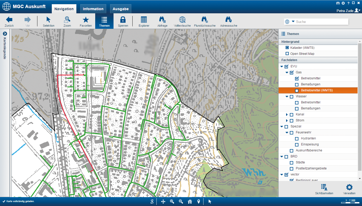
- Flexible background data from cadastre, OpenStreetMap or other services
- Performant, topic-controlled presentation of the operating resources
- Ability to combine with external WMS sources
- Display of assets in a Smallworld-like representation
- Display of the attribute data for assets
- Functions for full-text search, enquiry, print, navigation
Convenient Navigation
- Integrated division-related full text search
- Favourites control
- Basic pan navigation
- Zoom
- Work history
Search Function
- Hierarchical search for addresses and registered properties
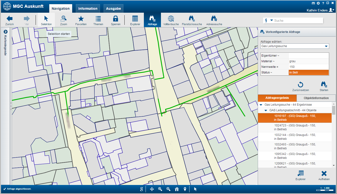
Enquiries and Explorer
- Configurable enquiries and result display
- Transfer to MGC Explorer which has an export function to XLS and CSV
Station's Internals
- Representation of stations' and cable distributors' internals
- Selection of internal objects
Google Transfer
- Jump to the desired position and zoom level in Google Maps
Auxiliary Lines and Redlining
- Recording of temporary auxiliary lines and areas with display of total lengths and area sizes
- Temporary redlining with optional representation of both elements in print
Output
- Snapshot function and convenient printing via configurable plot templates including automatic and free text fields
- Optional module for segmented printing
Optional Serial Printing Module
- Convenient creation of single-line plots or serial plots via a freely definable area
- Output including overview sheet and numbering
MGC Offline Enquiry serves the efficient mobile use of GIS data in offline operation. The high-performance and easy-to-deploy app reliably supports the various work processes in the field of network data.
The most important goal is simplicity of use and ruggedness in order to make the potential of GIS data available to employees without online access. The app uses vector data, which makes the mobile data enquiry lean and fast.
- High-performance and efficient GIS enquiry for offline operation
- Topic-controlled presentation of assets based on vector data
- Comfortable and intuitive operation with gesture control
- High-performance export process
- Independent from Smallworld GIS due to central MGC Warehouse
- Smallworld-like representation of the equipment
- Display the attribute data for the objects
- Versatile navigation options and search functions
Convenient Navigation
- Mouse or gesture controlled zoom and pan
- Favourites control
- Optional topic control via tree directory or icons
- Dynamic map rotation
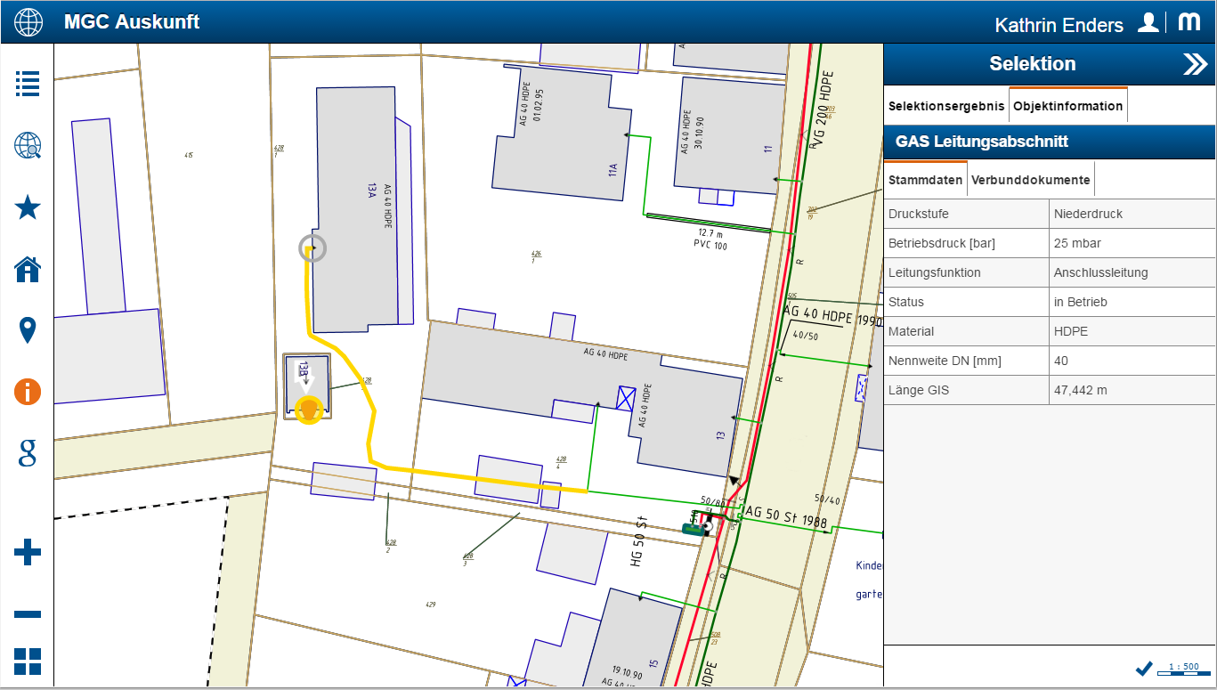
Attribute Data and compound files
- Point or area selection
- Clear display of technical data for the equipment
- Support of compund files
Enquiries
- Configurable enquiries for any objects with transparent result display
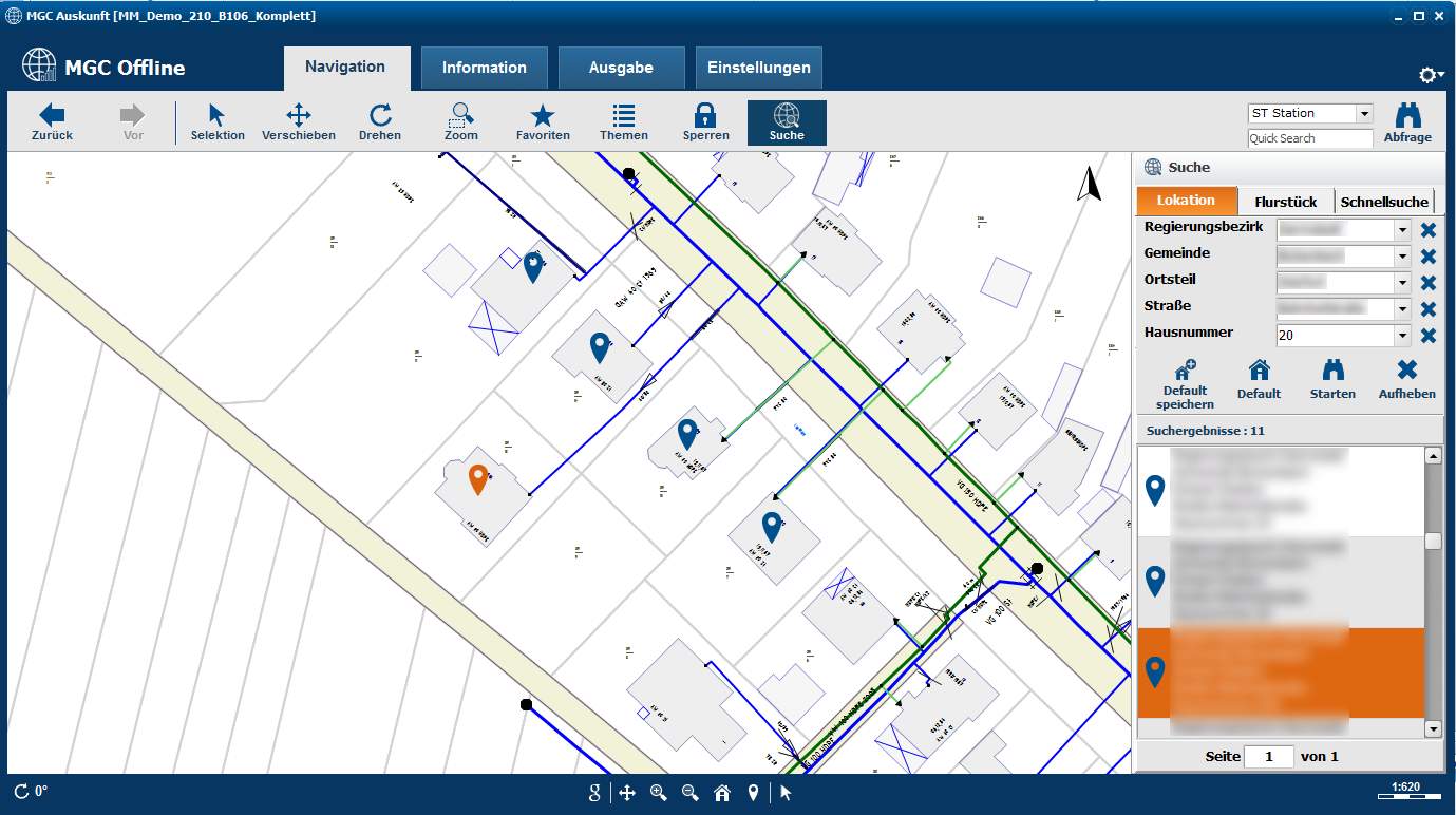
Address and Parcel Search
- Comfortable hierarchical search for addresses
- Optional additional module: Search for parcels
Stations' Internals
- Depiction of stations' and cable distributors' internals with the possibility of selecting the internal objects
Measurement and optional module for redlining
- Length and area measurement
- Recording of redline objects with use of predefined text modules and display in print
Google Transfer
- Jump to the desired position and zoom level in Google Maps
Output
- Snapshot function and printing via rotatable plot templates
- Optional add-on module: Printing seperated by utilities
GPS and Configuration
- GPS positioning with the possibility of dynamic map tracking and rotation
- Tool for configuring the application
Extract Management
- Convenient extract management for downloading or updating extracts
- Filter function
- Definition of the standard extracts
- Dynamic display of the availability of new extracts in the application
The recording of simple asset data changes or other manual notes on the assets is often prone to errors, time-consuming and does not conform to recommendations or regulations of the utility industries.
With MGC Update, the manual processing of map changes and long delays in the GIS department are a thing of the past. Changes to asset data are digitally processed using object-specific forms. Notes or changes in the network are just as easy to capture using redline objects. MGC Update can be used both in the MGC web client and in the MGC offline client in the same manner.
After releasing (MGC online app) or after synchronising (MGC offline app), the updates are available to all users. They are clearly visualised as an additional topic showing the attribute data changes.
The module MGC Process Management for Smallworld GIS is available for the comfortable further processing of the collected data. Here the data changes can be conveniently imported, processed or rejected. This means that the network data processing can be continued without media discontinuity, thus saving time and resources..
Comfortable Functions
- Entering or correcting attribute data in MGC
- Using preconfigured change forms for specific network objects
- Writing change notices or comments directly into the MGC graphic via redline
- Simply attaching additional documents
- Synchronising and visualising changes in GIS
- Making daily updated changes visible for all users in the MGC
We have developed MGC Touch Web Enquiry especially for the requirements of the field service. The app is characterised by extremely simplified operation and combines target-oriented functions with the advantages of touchscreen operation of modern tablets.
The most important goal of the app is to support the various mobile work processes with fast and simple network data enquiries and thus the effective use of GIS data and its potential.

- Web-based enquiry of GIS data for mobile use with optimised touch operation
- Flexible background data from cadastre, OpenStreetMap or other map services
- Performant topic-controlled presentation of the operating resources
- Smallworld-like representation of the equipment
- Display the attribute data for the objects
- Navigation functions and integrated full-text search
Touch-optimised Navigation
- Zoom and pan via gesture control or button
- Topics control
- Favourites control
- Jump to the current GPS position
Search Functions
- General, address-based and division-specific full-text search
Selection
- Clear presentation of the factual data on the equipment
- Support of compound documents
Stations' Internals
- Representation of stations' and cable distributors' internals with the possibility of selecting the internal objects
Google Transfer
- Jump to Google Maps with transfer of the current position and zoom level for further navigation
With MGC Concession, municipalities receive network data that are geographically, attributively and content-wise limited to their designated area. This web-based application is ideal for network operators who provide services for municipalities or other network operators.

- Network data enquiries for municipalities
- App for network operators who provide services for other utility companies or municipalities and specifically provide their data for information purposes.
- Spatial authorisation to restrict the map enquiry to a specific network area
- Attributive authorisation for restricting the attribute data enquiry
- Limitation of content to background maps and special data, e.g. gas data of a gas concession
- Comfortable user interface and self-explanatory menus
- Extensive range of enquiry functions
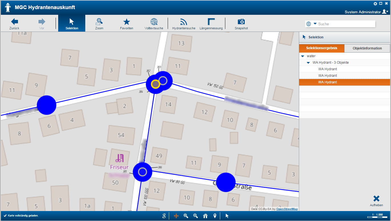
The MGC Hydrant Enquiry supports fire brigade operations as well as contracted service providers who, for example, carry out a hydrant inspection. The aim of the app is to quickly and conveniently locate the relevant resources of the water supply network.
- Lightweight web app with the focus on hydrants
- Clear application for easy operation
- Specially highlighted display of hydrants
- OSM background data and essential resources of the water supply network
- Display of technical data on the hydrants
- GPS-based radius search of the closest hydrants
Optimised Visualisation
- Enlarged view of the hydrants
- Familiar background data through OSM usage
Hydrant Search
- Determination of all hydrants within a radius of e.g. 30 m to the current GPS position
- Display of hydrant information by selection
Full-text Search
- Convenient navigation via addresses or hydrant data
Other Functions
- Google transfer e.g. for routing
- Length measurement
- Snapshot function
- Favourites control
This MGC Street Lighting enquiry system gives detailed information on municipal street lighting assets. It makes use of QR codes and GPS localisation.
The MGC Click Before You Dig offers the view on the essentials by the pure information purpose and its reduced functional range. It is an app for fast map enquiry for your employees and enables them to perform a high-performance full-text search across the entire MGC database.
We offer you the possibility to design specific apps according to your wishes and to optimise them for the best possible process support. This includes, for example, extended resource information with data from third-party systems such as ERP or DMS.