operated and maintained externally


Geodata and Application Service for Network Operators
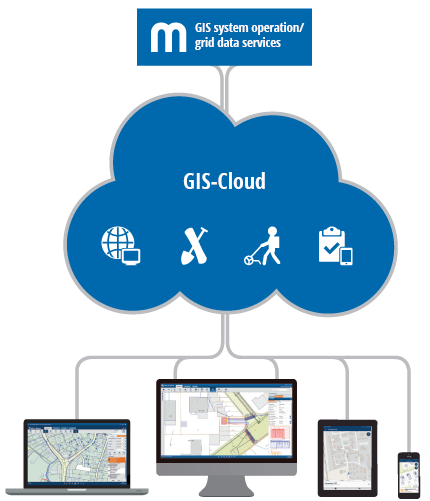
GIS in the Cloud
Now you can use GIS data easily, cost-effectively and securely. Without large investments in hardware, software or training, your employees and partners can access the network data and the most important functions of the GIS via the internet and can call up and change the required information at any time.
Your Cloud Construction Kit
Geodata and Application Service – Network operators select their individual service level at Mettenmeier and concentrate on their core strengths.
Your Building Blocks
System Operation and Cloud Hosting
With Mettenmeier, your network data is in the best hands. For their documentation and maintenance, we usually use Smallworld GIS with its sophisticated applications for supply and sewage networks. Mettenmeier allows you to freely choose the scope of services you need.
We do the administration and configuration for you, as well as taking the responsibility for the stable system operation, including all updates and upgrades.
On request, we can provide a cloud server together with local data centers on which your data and applications can be securely hosted.
We do the administration and configuration for you, as well as taking the responsibility for the stable system operation, including all updates and upgrades.
On request, we can provide a cloud server together with local data centers on which your data and applications can be securely hosted.
Network Data Services
The benefits of your cloud solution depend to a large extent on the quality of the database and the map material. In addition to providing the system, we can also take care of your network data if requested.
From joint data maintenance to the complete outsourcing of important GIS services including surveying and further data use in the form of analyses and statistics – you choose your individual service level and always keep track of the up-to-dateness, progress and quality of your database.
From joint data maintenance to the complete outsourcing of important GIS services including surveying and further data use in the form of analyses and statistics – you choose your individual service level and always keep track of the up-to-dateness, progress and quality of your database.
GIS Apps
GIS in the cloud means that you can conveniently use the MGC product family as a service. This includes a large selection of GIS apps to visualise your network data and use it company-wide in working processes – with independent technology and highly performant clients.
Whether in the office or on the go, on notebooks, tablets or smartphones, online or offline, as a map enquiry system for third parties or in a portal: MGC is your solution of choice. For example, you can use MGC Task to process maintenance tasks. In addition, MGC offers you update functions for entering data or overview sketches yourself and transferring them to GIS.
Further information on the available MGC apps can be found here.
Your advantages are obvious
The efficient service bundling at a specialist such as Mettenmeier particularly relieves small and medium-sized public utilities of the tasks involved in the management of their GIS. Your advantages are obvious:Your advantages
- Focus on your core activities
- Fast access to specialists and know-how
- Low resource and capital commitment plus savings in ongoing IT costs
- Always the latest technology and state-of-the-art applications
- Plannable costs through monthly billing for hosting, usage, maintenance, updates and upgrades
- Additional reliability through offline-capable GIS apps
Do you have any questions or requests?
Contact